
Geomorphology is key to ground modelling
Geotechnical • Industry matters
 Welcome to the world of geomorphology. Ground & Water Engineer, Chris Gordon has an MSc in the discipline and is a strong advocate of it. Below he highlights why geomorphology is an important consideration for any modern geotechnical and geoenvironmental consultancy.
Geomorphology is the study of land forms, the materials of which they are made, the dynamics by which they are made and how they function. It is at the centre of understanding what earth materials are, how they interact, how they originated and how far they extend and where similar conditions and materials are likely to occur. In essence, it focuses on the combinations of composition, stratigraphy, shape and topography of ground materials and how they interact and affect each other.
Here in the UK, we are very proud of our greenbelt countryside and national parks. The invaluable benefit these precious landscapes provide, are therefore heavily protected and so avoid the glare of onset urban sprawl. This places relentless pressure at the heart of our brownfield sites and increasingly, more challenging sites are becoming repurposed to facilitate demand. Mixed use or residential developments now feature in former industrial or commercial land, contaminated land or land with significant engineering or geological challenges. This alternative movement requires an alternative way of thinking and a deeper understanding, away from traditional desk-based assessments. Experience in a wide range of relatable disciplines and a geomorphological understanding, all contribute to building a 3D conceptual site model with a short and long-term consideration for ground conditions, how various geological, hydrological, and geomorphological systems interact and influence engineering solutions.
Ground models should be a fundamental outcome from all site investigations for civil engineering development and planning projects. Without them, it is not possible to: define the ground conditions; identify any geohazards or other engineering constraints; identify potential resources; provide a basis for construction tendering; establish risk registers; determine reference conditions; design the works or evaluate the environmental consequences of projects. A methodology for ground model development has yet to be fully established, but understanding geomorphological processes and landforms is central to the creation of effective models. Therefore, it is necessary to develop a methodology that ensures geomorphology is fully integrated into the already well-defined approaches for investigating and interpreting the geological and geotechnical conditions. This happens most effectively where geomorphology is seen as part of engineering geology and is fully integrated in the site investigation process. A large proportion of geomorphological research is undertaken as part of physical geography and is not widely accessed during standard desk studies. Engineering geologists need to access this high-quality research and incorporate it into ground models that are presently biased towards geology and geotechnics.
Case Study 1
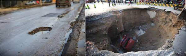
To the untrained eye, an inconsequential undulation or pothole in the road can be nothing more than just that. Transport yourself to the same location a year later and suddenly patching up seems futile. The road shown above was constructed on loosely consolidated sandstone that was prone to entrainment from groundwater and throughflow movement. The gradual removal of lax sandstone particles and dissolution of the carbonate cement bonding them together, attributes to a gradual void forming and eventual collapse once the overlying structural can no longer support their own weight.
In this case, only factual information was obtained to inform of local ground conditions and soil strength parameters relevant to the road’s construction; including CBR plate load testing and a limited intrusive ground investigation, featuring a number of shallow boreholes. Little consideration was given to the surrounding environs and geomorphological significance at this location.
Case Study 2
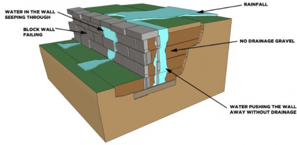 Residents identified a series of widening cracks and displacement within their property boundary retaining wall structure and sought help from a structural engineering consultancy, which recommended that an expensive intrusive soil nail anchorage scheme was introduced, pinning the structure into the underlying sandstone bedrock it retained. Whilst there is no doubt the solution would provide improvement to the short-term stability of the wall, no consideration was given to the wider geomorphological significance, site setting or what processes/interactions were in operation.
The retaining wall was cut into the base of a larger downhill slope within a wider catchment area. Ground behind the top of the wall subsided as though it had been removed and crucially, the retaining structure featured no drainage holes (weep holes) therefore it was concluded, this was an issue relating to insufficient drainage and hydrological location rather than structural. Groundwater flowing downhill within the catchment, was building up behind the wall, unable to pass through it, causing hydraulic pressure and pushing the structure outwards. Excess surficial water was found to outflank, flowing laterally along the wall removing lax material and attributing to localised undulations. Ground & Water engineers applied their geomorphological understanding and specialist knowledge and quickly recommended an alternative solution that would work with the geomorphological setting and provide a long term and reliable fix. It was advised that a series of drainage weep holes were installed into the wall to relieve hydraulic pressure and a surface and ground drainage scheme was installed to manage groundwater and material washing from behind the wall structure. This saved the client money, time and of course, the wall lives on.
Having a background in physical geography and MSc in engineering geomorphology, it is truly refreshing to work with a consultancy like Ground & Water that promotes the implementation of specialist disciplines and outside-the-box thinking. The outcome net effect is something that truly benefits all parties. Independent, well developed and more experienced engineers, delivering higher quality site specific and accurate solutions. Having an in depth, 3D geomorphological take on the traditional conceptual site model, will ultimately save the client time and money.