Chalk dissolution…finding the weaknesses
Geotechnical
Much of the south east and southern England is characterised by its chalk bedrock. As Roger Foord highlighted in his 10 Mar 21 post, this shapes the topography of the landscape that we see today.
This week Ground & Water Engineer Myles Finnerty provides an insight into the sub-surface geotechnical problems, that chalk deposits can pose on a construction site, with reference to a recent case study from a site in Watford, Hertfordshire.
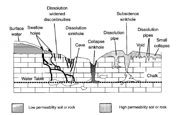
To begin I thought I would briefly explain how dissolution features are formed; the common types that are encountered, along with challenges that they pose to construction. Dissolution is a chemical weathering process where slightly acidic liquid, typically surface/ground water, dissolves calcium carbonate within chalk. Over long time scales (>10,000 years), this opens up a variety of features within the chalk, including: swallow holes, dissolution widened discontinuities, sink holes, pipes, voids and forms an irregular rockhead interface as shown on the image below.

As the figure above clearly shows, dissolution features create an extremely complex and unpredictable geological profile, which gives rise to a number of construction related risks. These include differential settlement – as the composition of the geology can vary both vertically and horizontally across the site – large settlements, due to extremely loose material infilling dissolution features or collapse of dissolution features below and reduced load bearing capacity of the chalk as natural discontinuities have been exacerbated.
As with any risk, the first requirement is to identify it. Locating dissolution features is challenging and can prove to be expensive. However, like all ground investigation it is money well spent in the long run, in order to quantify the potential risks. Identification of dissolution features is carried out in two parts: a Desk Study reviewing secondary information, followed by at least one round of on-site investigation works. Both a Desk Study and Intrusive Investigation are required since dissolution features can show no visible signs at the ground surface, particularly in areas with thick bands of superficial granular deposits, and so a Desk Study alone can miss underlying features.
A Desk Study involves a detailed site-specific review of historical maps and aerial images, LiDAR data, geological maps, the Peter Brett Associates Database and GroundSure Datasheets. This aims to determine if dissolution features are likely to be present, based upon the ground condition, looking for any mapped features of interest on-site and in close proximity to the site and a search of recorded natural and man-made cavities in the local area in similar geology. Once complete, this can guide the methods of on-site works and also target specific areas on-site.
Site works methods for investigating dissolution features are split into geophysical and direct methods; both of which have pros and cons that need to be weighed up. Geophysical methods of detection can involve the use of seismic, gravitational, magnetic, resistivity and ground penetrating radar on the site to measure the physical properties of the underlying soils. Once collated, the data is reviewed and any anomalous results can indicate the presence of a feature. For example, the image below shows a cross section of results identified whilst carrying out a microgravity survey with potential solution features indicated. The benefits of using geophysical methods is that large areas can be covered in a relatively short amount of time and some equipment setups can allow a real time stream of data to be reviewed. The drawbacks are that it is most effective at identifying shallow features, it can require follow on drilling works to confirm geophysical data and relies upon the fill material within dissolution features to have markedly different properties to that of the chalk to be able to be identified.

Direct methods involve physically measuring a certain property of the chalk either in-situ or from sampled material. Methods typically involve drilling, cone penetrometer testing, dynamic probing or trenching. Once results have been collated a vertical profile of the physical properties of the chalk can be produced, allowing features to be identified from anomalous results. The pros of these investigation techniques, are that in some methods samples can be recovered for laboratory testing and secondly a vertical profile of the geology can be attained to much greater depths than possible with geophysical methods. The drawbacks are that it is considerably slower than geophysical techniques, it can be very expensive and often requires a cleared site in order to gain full coverage.
The identification can often require a combination of geophysical and site investigation techniques to produce the most accurate picture of the site conditions. As always a measured approach is required, as cost is often the limiting factor when determining methods of investigation to be carried out.
Once identified suitable mitigation measures can be determined to minimise the risk to the proposed development. This is often through changes to the proposed foundation scheme, the need for ground improvement techniques or stringent requirements for surface water disposal to be carried out off-site. The exact requirements for each site will need to consider the proposed development and individual site conditions.
If chalk is known to be the underlying bedrock of a construction site, Ground & Water would always recommend that a chalk dissolution risk assessment is carried out, as it enables construction risks to be minimised at an early stage of the development process.
Read about how Ground & Water identified massive variances in the integrity of the underlying chalk of the Watford re-development site HERE

