Damaging dissolution features defined
25th March 2021
Geotechnical • Specialist Services
Desk Study and Site Investigation, reveals massive variances in the integrity of the underlying chalk bedrock at Watford redevelopment.
Our Client
Ground & Water’s client was a property developer working in Hertfordshire
Preliminary-Assessment
Watford is situated on the ‘Upper Chalk’ of the Chiltern Crest. During phase 1 reporting, a chalk dissolution risk assessment was carried out and identified the site to be at a low risk from ground dissolution stability hazards owing to the geology of Winter Hill Gravel Member overlying the Seaford Chalk Formation and Newhaven Chalk Formation (Undifferentiated). This classification means that soluble rocks are present within the ground and that some dissolution features may be present. The site and surrounding environs were also identified as an area where sporadic underground mining of restricted extent may have occurred, although historical maps did not identify any associated features marked on-site or within 250m. LiDAR imagery was reviewed; however, due to the heavily built-up nature of the site and surrounding environs, no meaningful data could be gained due to interference and shadowing from surrounding structures. The Peter Brett Associates Database revealed no features recorded within 250m of the site; that said, three sinkholes and five solution pipes were recorded at two sites between 340 – 479m to the east of the site within the same geology.
Our Challenge
The site was located within central Watford in an area characterised by a mixture of residential and commercial properties. The existing development consisted of a block of flats with associated car parking and soft landscaping. The proposed development comprised the demolition of the existing structure with the construction of a new direct replacement, like-for-like block of flats. Ground & Water was instructed to carry out a comprehensive site investigation, including the production of phase 1 and phase 2 reports.
The Ground & Water Approach
As a result of the phase 1 Desk Study, a first round of site investigation was undertaken including two cable percussive boreholes to confirm the composition of the underlying geology and gain strength profiles of the chalk. Geophysical methods of site investigation were not considered to be suitable at this stage due to the limited area available for investigation prior to demolition works. The results of the cable percussion drilling revealed the Winter Hill Gravel Member to be ~ 3.00 – 3.50m thick overlying the Seaford Chalk Formation and Newhaven Chalk Formation (Undifferentiated) to the base of each borehole at 20.00m below existing ground level (bgl). A soft horizon was recorded within one of the boreholes at the boundary between the overlying gravels and chalk where an ~1.00m thick band of soft clay, with SPT “N” Values of five, were recorded. Due to the classification of the site, further dynamic probing was carried out at six locations across the site, to determine the extents of the soft horizon at the boundary of the superficial and bedrock deposits.
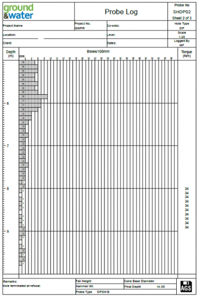 The results of the probing highlighted two areas with soft spots/suspected dissolution features at varying depths between 3.00 – 13.50m bgl. The suspected dissolution features were identified by the extremely low blow counts recorded, between 0 – 3 (see image to the left for example log). Subsequently after discussions with the client and NHBC, it was determined that further dynamic probing would be carried out post demolition across the site in a 5m by 5m grid to a depth of 15.00m bgl to identify the locations of dissolution features and the competent chalk below.
The Outcome
The further probing identified the varied rock interface and dissolution features across the entire site both laterally and vertically. To assess the data the trial hole logs were presented visually and colour coded to identify features. The equivalent SPT “N” Blow counts have been torque corrected and then banded with blows of 2 – 8 colour coded yellow and values of 0 – 1 colour coded red (see example table below). The results show massive variation in the strength characteristics from one location to another at the same depths across the site.
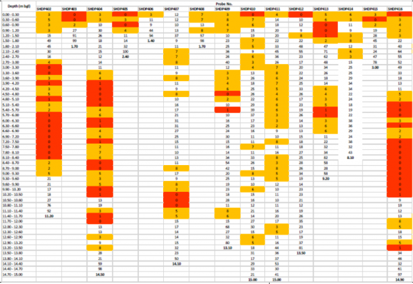
The subsequent foundation recommendations for the site were for either a shallow raft foundation or piled foundation solution to bypass the locally soft and weathered chalk to a depth of 15.00m bgl. Further to this was the recommendation that it would be best practice for surface water to be discharged off-site to prevent the worsening or creation of further dissolution features.